Newcastle City Council
Tree preservation zone
There is a problem
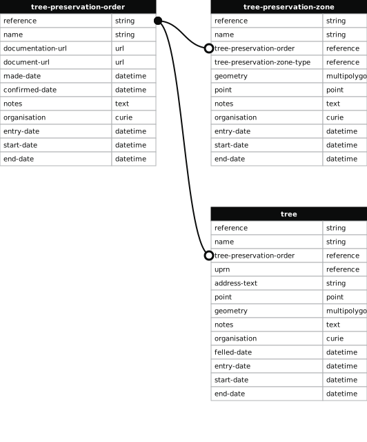
- 1000 entries with tree-preservation-order field must match the reference field in the tree preservation order dataset
JESMOND THREE SIXTY, ARCHBOLD TERRACE, NEWCASTLE UPON TYNE NE2 1DB
- reference
- 2019/010.G2
- name
- JESMOND THREE SIXTY, ARCHBOLD TERRACE, NEWCASTLE UPON TYNE NE2 1DB
- tree-preservation-order
- 2019/010
- tree-preservation-zone-type
- group
- geometry
- MULTIPOLYGON (((-1.606372 54.980817,-1.606341 54.980828,-1.606405 54.980911,-1.606456 54.980967,-1.606637 54.981184,-1.606702 54.981268,-1.606715 54.981306,-1.606708 54.981369,-1.606656 54.981433,-1.606608 54.981471,-1.606553 54.981506,-1.606584 54.981519,-1.606675 54.981447,-1.606710 54.981413,-1.606739 54.981359,-1.606743 54.981305,-1.606733 54.981262,-1.606657 54.981150,-1.606557 54.981033,-1.606478 54.980945,-1.606387 54.980840,-1.606372 54.980817)))
- point
- POINT (-1.606584 54.981153)
- notes
- These data are update live via a feed to NCC's Tree Managament System, EzyTreev
- entry-date
- 2022-07-01
- start-date
- 2019-04-12
- end-date
How to fix this issue
Your data is missing a tree-preservation-order.
The tree preservation zone guidance explains how to fix the issue:
tree-preservation-order
The reference for the tree preservation order that covers this zone.
How to improve Newcastle City Council’s data
- Fix the errors indicated
- Use the check service to make sure the data meets the standard
- Publish the updated data on the endpoint URL